Master plan Hangzhou New District
Hangzhou

- Architectes
- UNStudio
- Lieu
- Hanghzou East, Hangzhou
- Année
- 2010 Client
Hangzhou Railway Investment Co., Ltd.
Data
Building surface: 1,741,000 m2
Building site: 367600 m2
Programme
Masterplan
Status
1st prize competition entry
Credits
UNStudio: Ben van Berkel, Caroline Bos, Gerard Loozekoot and Filippo Lodi, Marcin Koltunski and Jae Young Lee, Colette Parras, Valerie Tam, Zhuang Zahng, Lingxiao Zhang, Ramon van der Heijden, Ren Yee, Bartek Winniki, Tomas Mokry
Advisors
Landscape: Or/else, Mark van der Bij
Engineering: Arup Shanghai, Frederik Wong
Renderings and Visualizations: UNStudio and IDF Global
Model: AMOD China
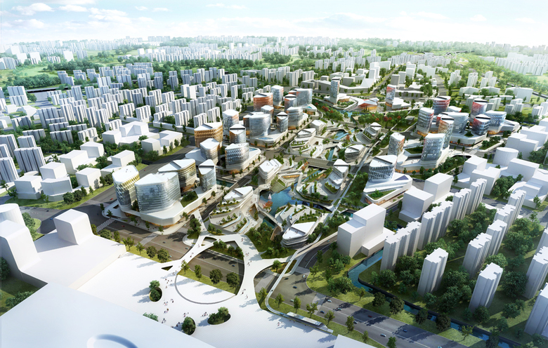
As with many cities in China, Hangzhou is undergoing rapid urban change. Whilst the city centre has been beautifully developed around the West Lake area, opportunities for industry and commerce have shifted the city’s expansion towards the riverfront area in the South and towards the East, where the Hangzhou New District is located.
Hangzhou has long been known for its lake district and green tea plantations. UNStudio’s approach to the masterplan for the New District therefore embraces Hangzhou’s longstanding natural and fertile identity whilst connecting the Old City Centre with the new Central Business District. Through the addition of a new and important railway hub, a new urban centrality is generated. By means of green corridors, water corridors, loose plantation structure, green roofs, urban cooling and warming strategy, green courtyards and sustainable living, the New District masterplan aims to bring Hangzhou to the forefront as the most advanced and sustainable urban plan of its scale.
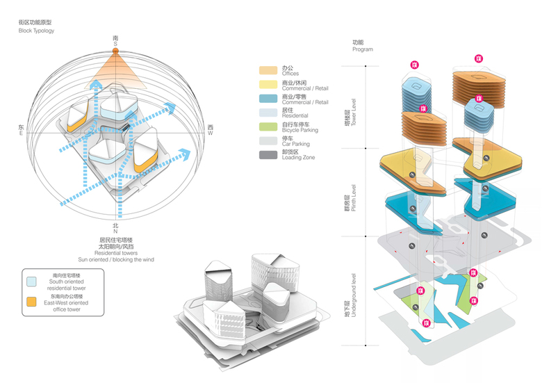
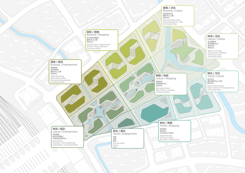
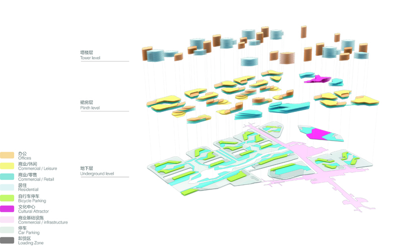
A comprehensive analysis of programme and site specific organisational principles has been used to rationalise connections with larger networks and integrate diverse parameters into a coherent design solution. The design aims to provide a sustainable approach in terms of ecology, economy and social cohesion by introducing a variety of public and commercial spaces which are strongly linked to the natural landscape. Within this new development both commercial development and amenable social locations reinforce each other through interconnection.
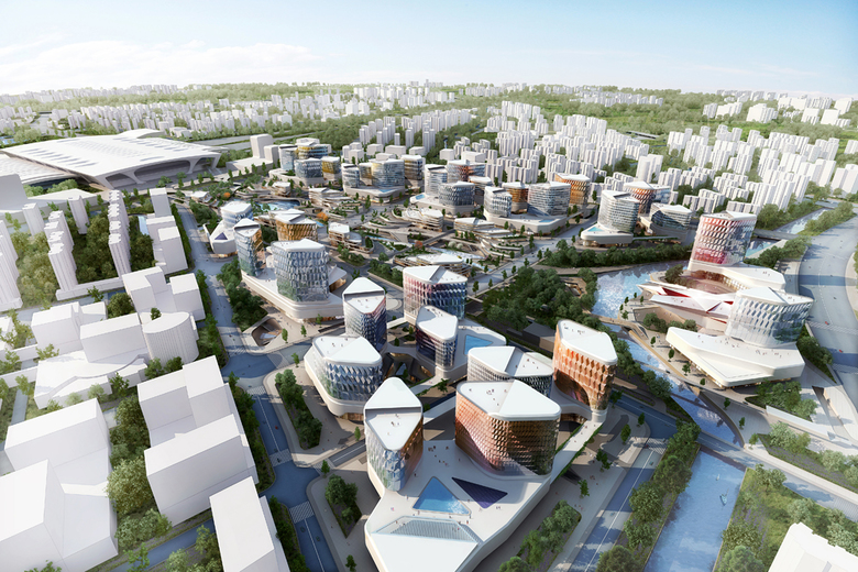
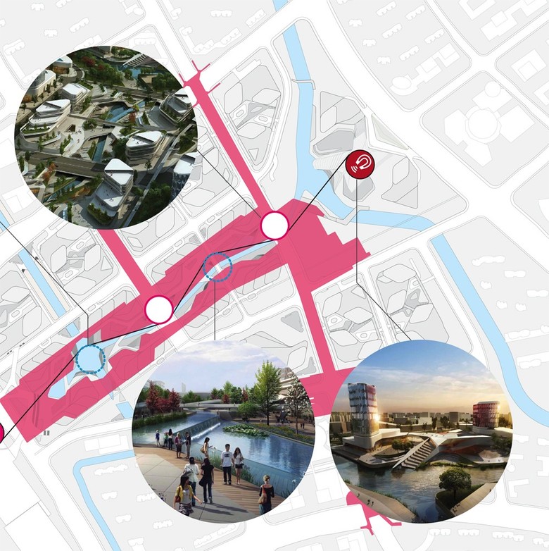
The design strategy for the Hangzhou New District pursues the idea of creating a green and lively pedestrian artery (above and below ground) as a means of connecting the main transportation hubs, main station and the metro station with the cultural attraction of the new Ecological National History Museum. The green pedestrian artery passes through a varied retail configuration; from restaurants, high-end retail outlets and public activities to the more local configurations of grocery stores and snack bars. The green design strategy aims to create a synergy between the environment and its users by offering spaces where high green density becomes a social and economical indicator for quality of life.
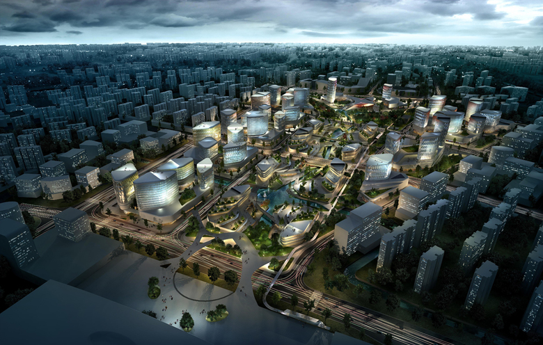
Heat Islands (cooling and warming wind effect) – Metropolitan zones are significantly warmer than their surrounding rural areas, mostly due to the extensive use of heat retaining materials in cities and the surplus heat generated by energy usage. The design for the Hangzhou New District aims to harvest this surplus energy by inducing air circulation within the pedestrian zones and thereby increasing user comfort. Wind corridors in low density areas will allow for better wind penetration, whilst the grouping of buildings reduces direct solar exposure. The addition of greenery further improves cooling effects for the central building complex. Temperature differences from the surroundings forces air circulation during periods of low wind, thereby reducing heat levels.
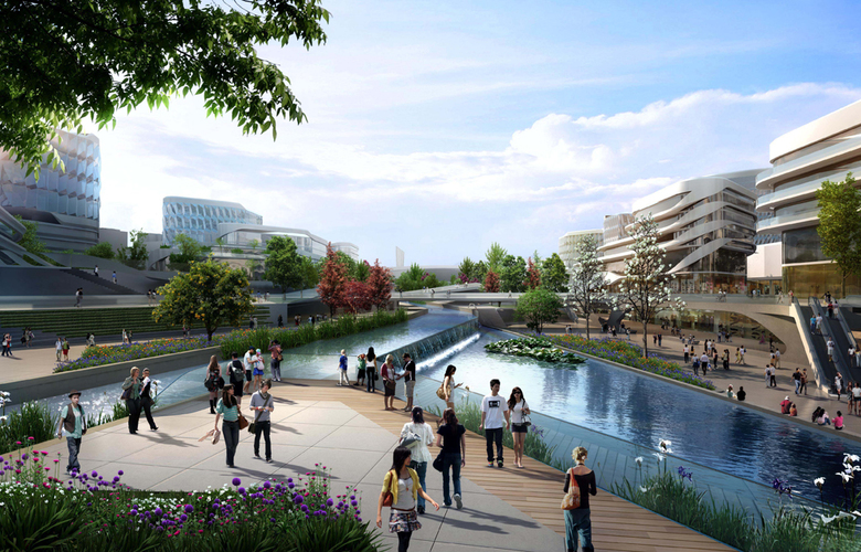
Green Corridors – The structure of the masterplan engages with the heat island effect through green corridors. The most relevant green corridor is the central axis which absorbs most of the heat exchange and contributes actively in the summer months by cooling through a central water stream. In the winter it warms by means of the seasonal changes of the plantation, which allows for more sunrays to filter through the trees. Secondary green corridors run transversal to the main axis and link both the green boulevards and the water to a riverfront experience, the green pedestrian walkways and retail functions.
Landscape strategy – Stretched between the railway station and the cultural ecological center as an important landmark lies the green-blue axis. This so called ‘urban valley’ is characterised by its lush green environment and its relationship to water. Along the axis an interweaving of logistics, connections, view points, leisure elements and points of rest occurs. This is expressed in a complex intertwining of green and water-related elements with solid features. The complex geometry of the inner and outer world always directs the visitor to the main guideline; the green-blue axis is an important structural element with a clear orientation.
Water reflects sunlight into shaded areas (provided by buildings), while trees provide a filtered atmosphere and shade. Water and trees also provide cooling. Above all, a visual connection is always be present between the existing water (river) and the incorporated water (green-blue axis).
Projets liés
Magazine
-
Swimming Sustainably
Aujourd'hui
-
Saving the Century and Consumers Buildings
4 days ago
-
This Week in Lawsuits
5 days ago